Cycling
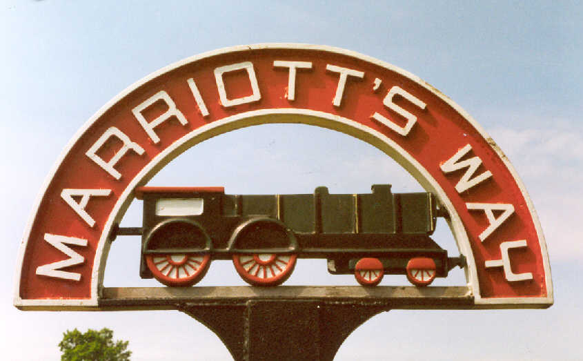
The Marriott's Way Reflections of our very enjoyable and adventurous days out cycling the Marriott's way |
Cycle Ride Three Approximately 33 miles The Marriott's Way Reepham to Norwich and return |
On
Wednesday 12th August 1998 Benjamin and I set out to full-fill a desire
we had since we enjoyed our first cycle ride in May last year, that
was to cycle "The Marriott's Way" from Reepham to Norwich,
On that occasion, we explored the route as far as Attlebridge where
we left "The Marriott's Way" on our return via Cawston to
Reepham completing our 16 mile circular ride. This ride was to be the
longest and most ambitious so far attempted by us, and like all our
circular rides we had to return to the car which we had parked at Reepham
station as usual, anyway we were up for it so here we go. We left Reepham station at 10.10 am with the usual essentials on board and decided to cycle the short distance to Whitwell & Reepham station by road, where we then joined "The Marriott's Way". A description of the route from Whitwell & Reepham to Attlebridge I've described previously in cycle ride No.1 so this account really begins as we depart Attlebridge on the 9 mile dash to Norwich. The surface was the best we had yet encountered on any part of the Marriott Way, very easy going even though it was a long steady incline up through Felthorpe woods, We hadn't traveled very far before we came across an original M&GN concrete mile post which has miraculously survived the years since the closure of the line, it stands a quarter of a mile Norwich side of Attlebridge station and reads 44/l, which means it stands 44 ¼ miles from Kings Lynn and a quarter of a mile from Attlebridge station. There are a number of these mileposts on the North Norfolk still in their original locations at Weybourne Kelling heath and Sheringham. I wonder how many more of these posts have survived. |
 |
|
 |
From 1916 a start
was made replacing wooden posts with concrete ones, which were triangular
in section with the mileage shown in a rectangular recess on two faces.
‘M&GN’ or N&S’ or the quarters in Roman numerals
were cast below the mileage. Mileposts were generally sited on the down side of the line. |
|
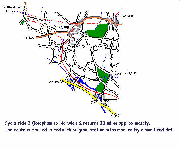 Route Map Reepham to Attlebridge |
 |
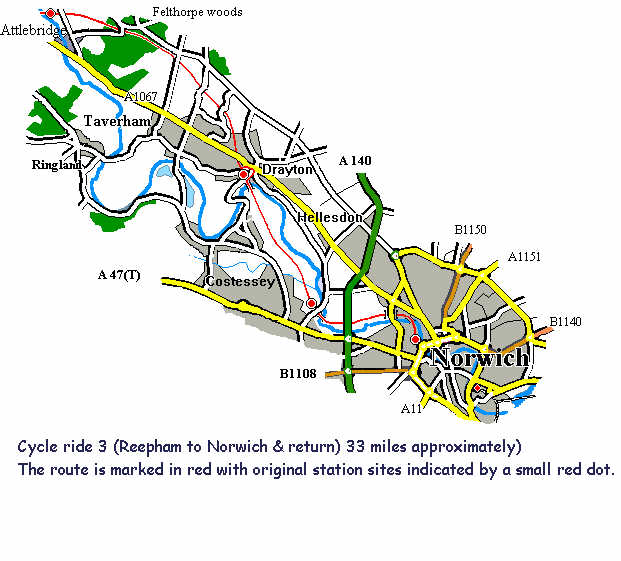 Route Map Attlebridge to Norwich |
The
view to the right across the Wensum toward Morton and Weston Longville
were very pleasant, wooden benches were observed along this section
so that wary travelers could rest and at the same time take in the view,
also observed were gas main markers which probably explains why the
surface was so smooth. The decision to use of old track bed as a route
for laying the gas main was obviously taken with a view to avoid the
disruption that occurs with such schemes and at the same time providing
a very acceptable cycling surface. We crossed the road known as 'fur
covert road' where originally the single track crossed by means of an
over bridge, long since demolished. As we head for Drayton the surface
is still very good, a pleasant surprise was in store when we arrived
at Thorpe Marriott, a new
housing development, thoughtfully named after William Marriott. Thorpe Marriott covers an area between the Norwich-Fakenham and Norwich-Reepham roads, I don't know why but we expected to find the path of the old railway swallowed up by this recent development but instead it continued like a green corridor through to Drayton, the only interruption was a single road crossing where road traffic actually has to give way to walker's and cyclist's using the path, at this point there is also a decorative sign marking the Marriott's Way. This has restored my faith in planners who all to often devastate such area's, I MUST CONGRATULATE THEM. As we approach Drayton, we first cross the A1067 Norwich to Fakenham road, at this point the railway originally passed under the road but the bridge has long since been demolished, we crossed the road on foot and continued toward the site of Drayton station, after a short distance we came across the point where the railway passed under the brick arched bridge carrying the Taverham road, we had to take a detour round what use to be Drayton station which is now occupied by several modern industrial buildings, nothing resembling the previous occupancy of this site ‘the railway’ exists today. |
 |
 |
 |
Whitwell
& Reepham Station |
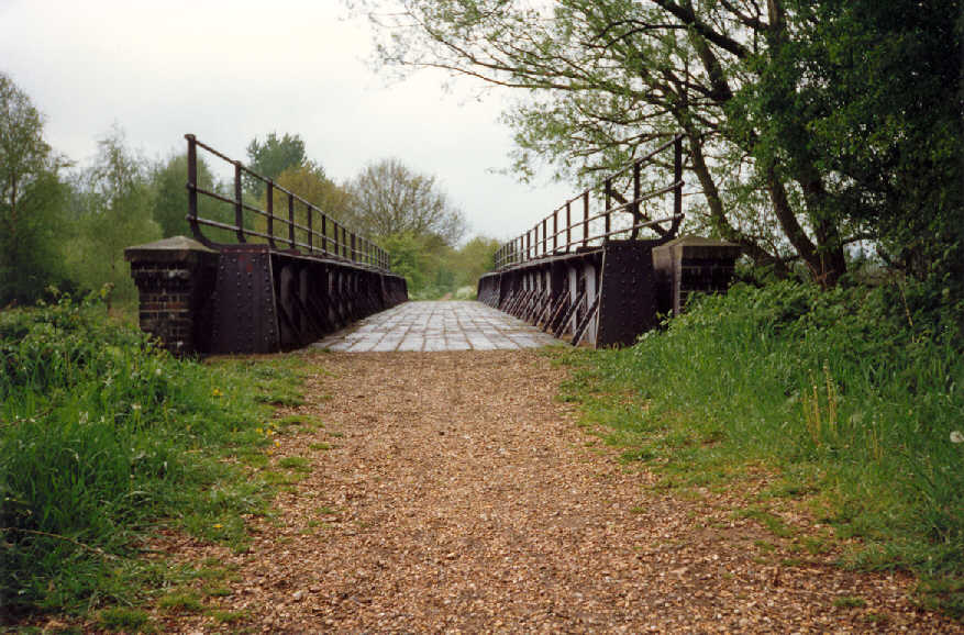
Bridge 276
Whitwell & Reepham |
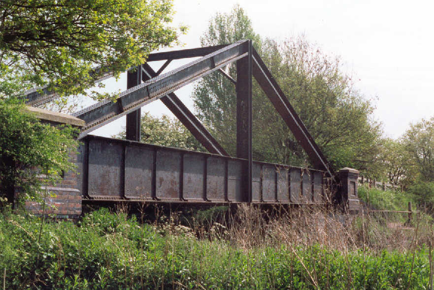
Girder Bridge
261 Lenwade |
 |
 |
 |
 |
'A'
frame bridge 249 at Hellesdon |
'A'
frame bridge 249 at Hellesdon |
Thorpe
Marriott |
A
frame bridge 254 Drayton |
We
rejoin the route in Costessey Lane at the site where the track passed
over this road, earth steps have been provided to aid access to the
top of the embankment from the small car park.
From there only a few yards away we could
see the “The M&GN
(save for a few hundred chains in North Norfolk) has gone forever and
lately one of the three ‘A framed’ bridges Ronald H. Clark By this time we
were quite hungry and as there was a bench close by which overlooked
the river, we decided to stop for some lunch. Unfortunately it wasn't
the most idyllic relaxing lunch break we had both deserved, because
I was aware that all was not well, my trusty stead had let me down,
'MY BACK TYRE WAS FLAT and all attempts to repair it failed, a shopping
trip to Halfords to purchase a new Inner tube was the only remedy, luckily
Halfords was only a stones through away, really it couldn't have happened
in a better place, it would really have spoilt our day if it had happened
at some remote location along the way. We arrived back
at Reepham at 4.15 PM, approximately 6 hours and 33 miles since leaving,
that did include an hour and a half stop at Norwich for lunch and essential
maintenance to my bike, so all in all we did exceptionally well. After
patting each other on the back, we loaded our cycles into the car and
enjoyed a well earned fizzy drink before driving home. |

